In Galicia we have one of the most extensive diffuse cities in Europe. 1.2M people live in it; 60% in single-family houses.
The entire road system is dominated by cars.
This intervention is a milestone. For 12years, together with the neighbors, we have worked to update/transform 5km of paths and roads as a pedestrian and cyclable street that connects us with nearby urban centers.
The intervention has only been running for 6months and has already become a new paradigm called to be replicated.
This candidacy presents a possible response to an environmental, technical and social challenge: How to intervene in low-density peri-urban environments to make them sustainable and provide them with public space in an efficient and replicable way?
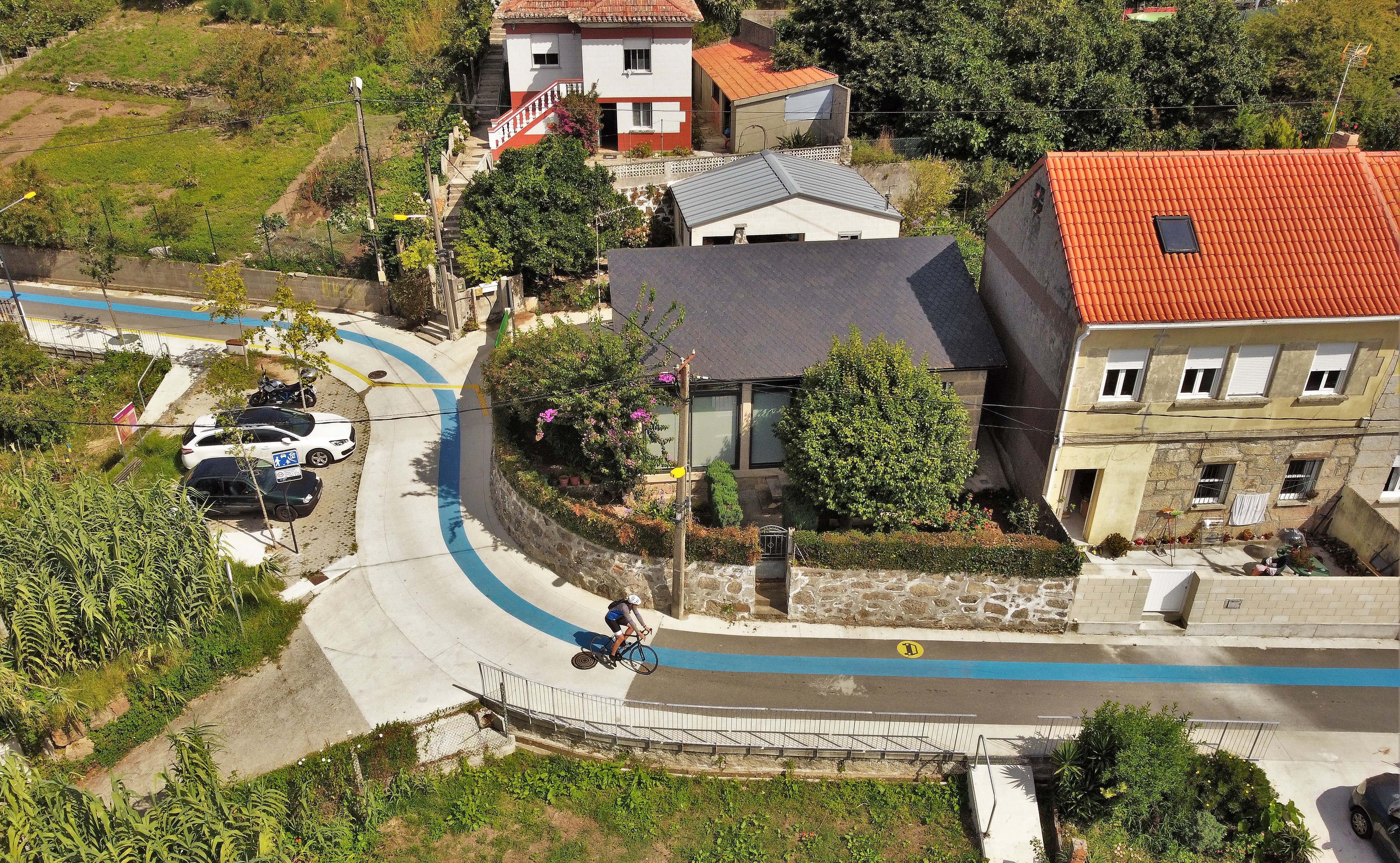
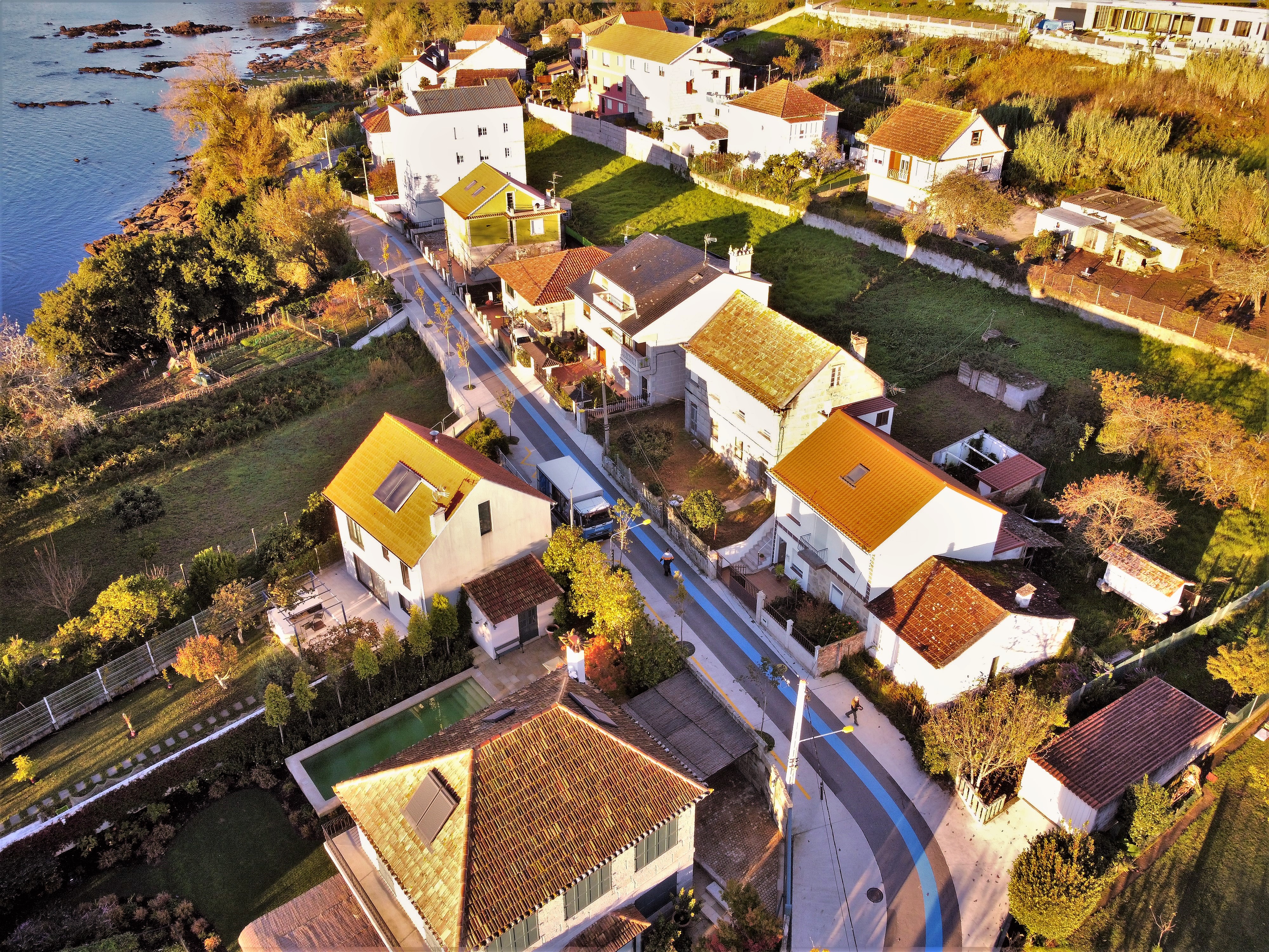
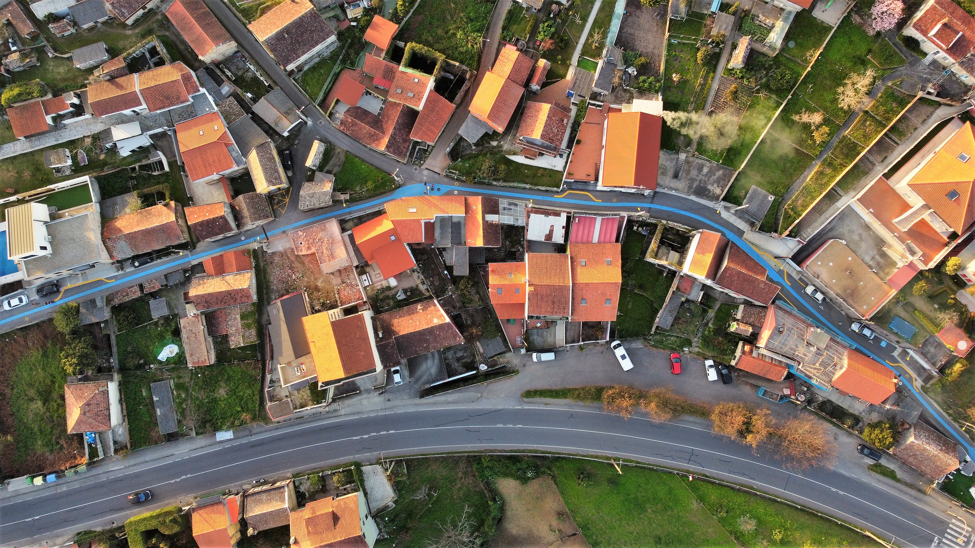
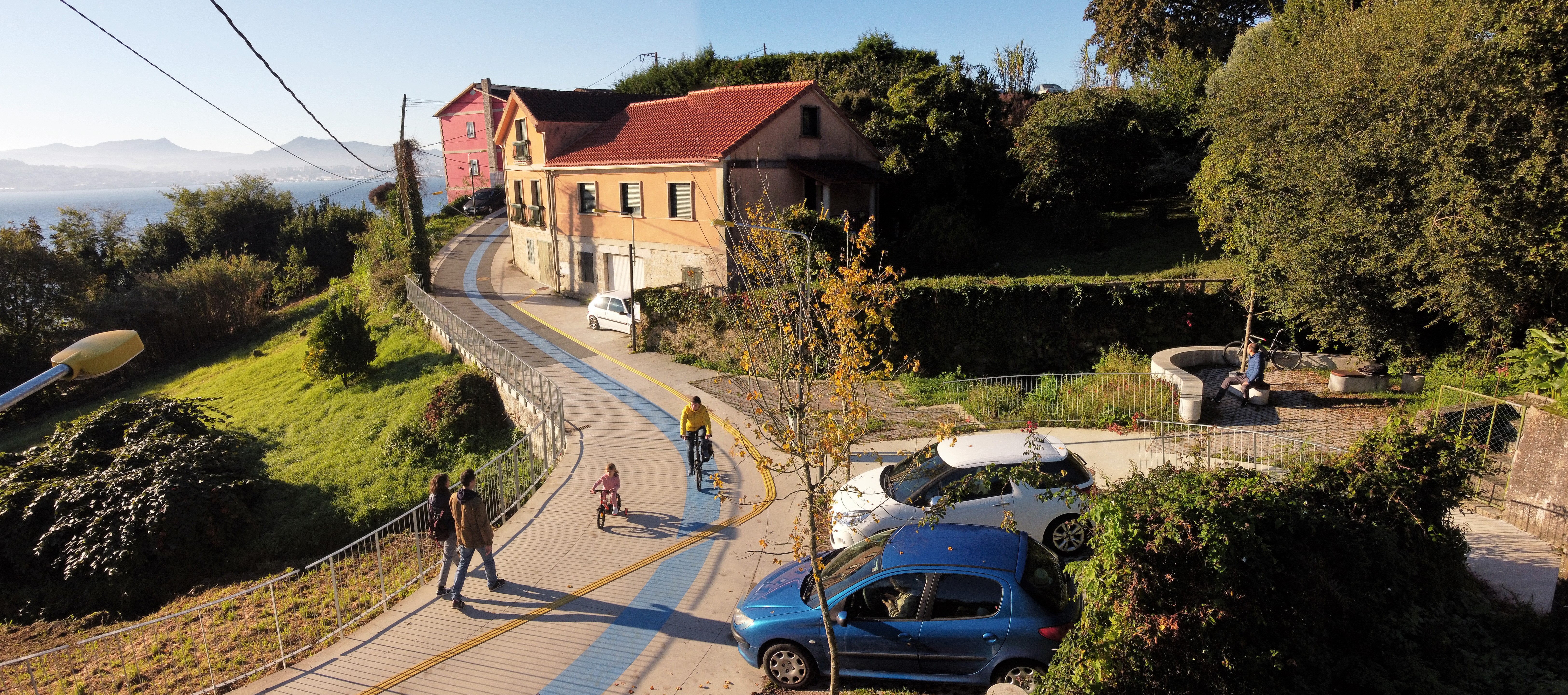
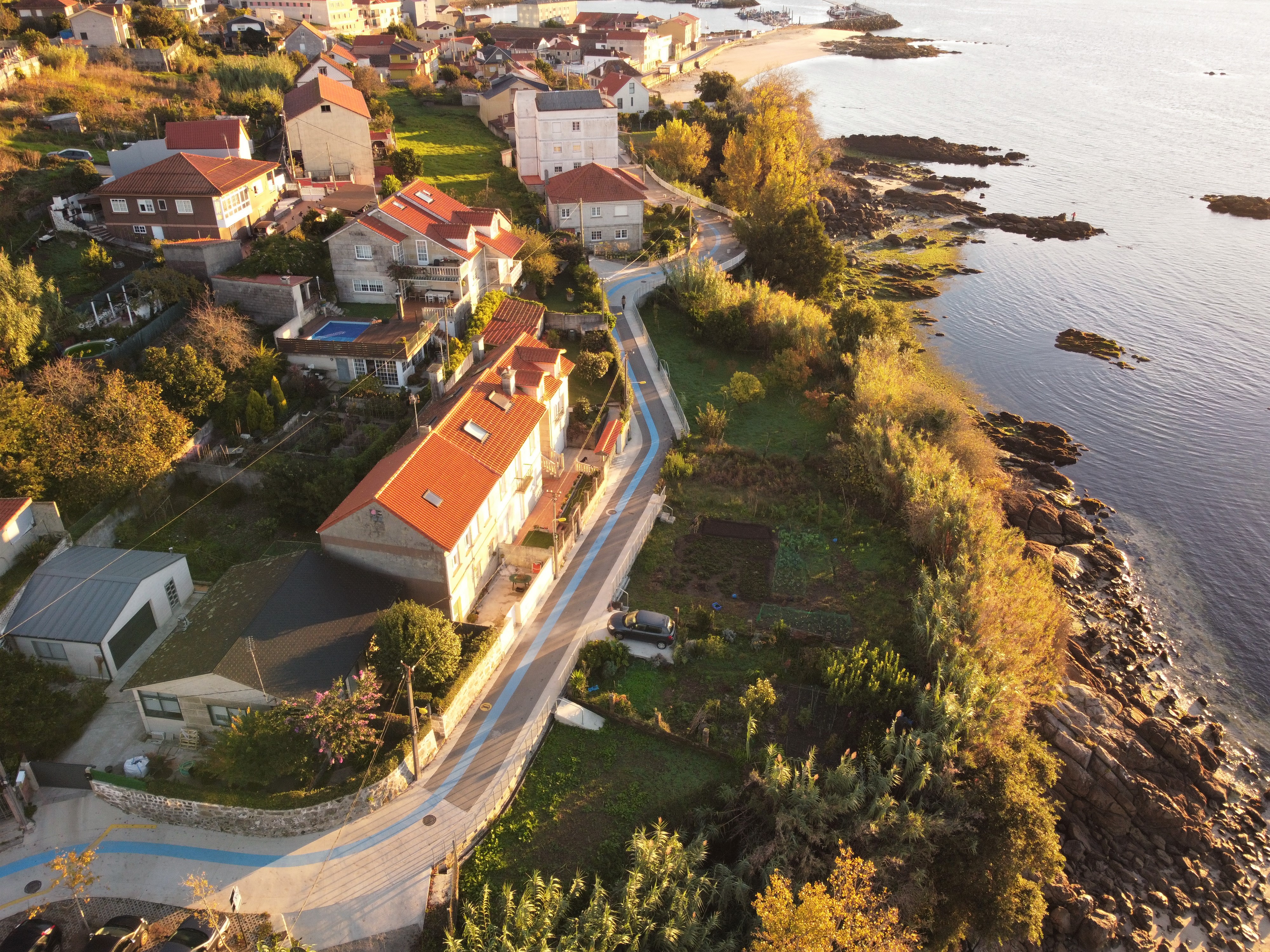
The Camino Real is a pedestrian and cyclable street that forms the backbone of a wide rururban (peri-urban) area, connecting it with the two closest urban centres (Cangas and Moaña) and at the same time these centres with each other. Public space and active, safe and inclusive mobility, all with a single intervention. The aim is to test a rururban regeneration strategy.
So that this street could happens we have:
- promoted and sustained a long process, establishing ourselves for this in the territory of intervention, to get to know it and to feel it as inhabitants... thus becoming valid interlocutors.
- restricted the circulation of automobiles (and we have reorganized circulation) in a very specific set of streets/paved roads.
- applied a myriad of micro-improvements with a tiny budget that we have stretched with a great deal of technical work.
- focused the layout on people, with an inclusive design and with a gender perspective.
- arranged open participation and negotiation channels, without interruption; this has been the key point that has avoided the usual conflicts when car limitations are to be applied.
For 12 years we have worked starting from the bottom, with neighborhood associations. We have provided plenty of endless hours of participation and mediation, anything necessary to conduct this governance process that affects an area of 50,000 inhabitants in the heart of the largest concentration of single-family homes in Spain: The Vigo-Pontevedra urban area (600K inhabs).
It is neither a river walk, nor a bicycle lane adjacent to a road. It is the prototype of the first 5km rururban pedestrian and cycling priority axis! It's done and it works. Let's do more.
Please highlight how the project can be exemplary in this context
To mitigate the dependency on the car and its excessive use that takes place in peri-urban areas
Providing these suburban contexts with a sustainable mobility infrastructure that connects them with the closest urban centers in less than 30 minutes (walking) or 15 minutes (pedalling).
We have achieved this by reordering motorized traffic on a set of existing streets and paths.
To reduce the number of motorized vehicles entering urban centers from their closest peri-urban areas
Creating a design strategy that consists of improving the connection of the urban centers of Moaña and Cangas with their first peri-urban ring (2.5km radius) to promote sustainable mobility in those short trips.
To minimize (economic, social and resource) costs
- By resurfacing only deteriorated road sections or those whose cross slope did not meet the accessibility parameters.
- By avoiding the construction of new cycle lanes and sidewalks, as well as clearing and demolitions common in civil works.
- By investing between 50 and 80% less than in any other redevelopment work.
- By designing local manufacturing elements not dependent on patents, which implies cost reduction in terms of commissioning, maintenance and replacement (railings, lampposts, benches, etc).
To improve existing living spaces
The layout of this artery of pedestrian and cyclable priority reuses (and updates) existing road infrastructure.
The extension of the road network has not been increased nor has the ground been artificialised.
Space has been found for more than 100 trees and drainage pavements have been introduced.
To improve the accessibility of the territory, especially that of the rururban inhabitants
The layout of this street is the most comfortable, useful and direct between the urban centers of Moaña and Cangas where facilities and services are found; including two maritime passenger transport stations, which lead to the heart of Vigo in 15').
Please highlight how the project can be exemplary in this context
To sew the different environments/spaces that make up the new street
We have combined specific micro-interventions to improve public space (more than 100) with other elements that are always present and that sew the entire itinerary.
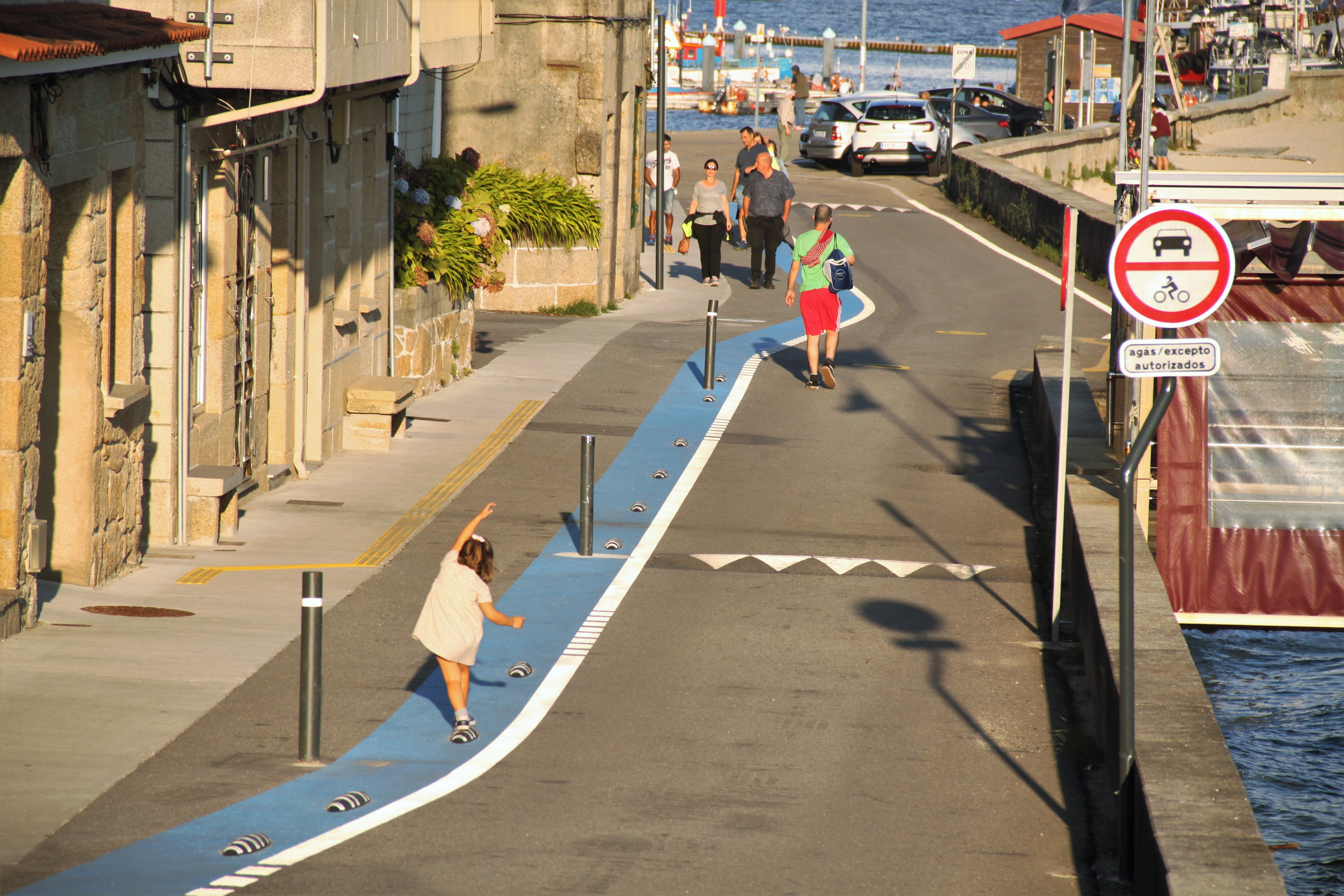
- Lighting, the disruptive blue band or the podotactile guides, transmit that we are always inside a space on a human scale that invites us to stay in.
- Furniture, stay areas, trees… dot the 5km of street and although the landscape changes as we go along, the street is just one, connecting everything, from Moaña to Cangas centers.
To generate a disruptive effect on the way of driving. The aesthetics of the new street must convey that the priority is for people (and bicycles)
Among other things, a 60cm cobalt blue band was designed that runs along the entire itinerary, as a perennial reminder.
To devise constructive solutions that dialogue with the rururban landscape (by definition hybrid and mutant, nothing canonical)
Practically all element and construction solutions have been specifically designed to adapt to the environment, without shrillness: from benches or lampposts, to railings, stairs, walls...
To place value on the countless heritage elements, of little individual relevance, but which appear scattered throughout the territory
Traditional walls, masonry stones and narrow alleys now have a brushed concrete pavement when meeting the path; creating a neutral surface that enhances them and which facilitates its cleaning
- Small irrigation channels that at times accompany the road have been preserved and repaired.
- Access stairs to cultivated areas have been pampered, so that they are also places of rest.
We have accompanied the surveyors, identifying meter by meter, everything that contained value, to consolidate and to repair instead of substituting. There seems to be a word for this: "kintsugi".
There is a very strong beauty, a harmonic chaos, a disarming honesty in this rururban cultural landscape of the Ría de Vigo.
Please highlight how the project can be exemplary in this context
To make possible the autonomy of people in their most daily movements, to increase their quality of life
Connecting peri-urban crowns with their (nearby) urban centers is a radically basic and essential issue in terms of inclusion.
To conquer the most useful route for active mobility, despite the fact that it involves a greater number of micro-conflicts with pre-existing uses (especially parking and shortcut traffic).
The street must be an inclusive space, always accompanied by houses. Rururban spaces make this idea possible (although complex to negotiate).
The easiest thing would have been to pave a sidewalk next to the road, or to build a seaside promenade, because it doesn’t dispute the leading role to cars... the revolutionary is a street.
To promote conciliation of caregivers, creating public space that is welcoming for dependent people
Gender perspective has been adopted as a core principle. This street allows children to recover autonomy and dependent people can walk alone; this greatly eases the hours of dedication to care work.
To achieve full accessibility for any type of diversity or need (motor, sensory, cognitive or due to age, race or sex).
We have corrected cross slopes, podotactile guides have been installed for the blind, as well as friendly colours and shapes for people with cognitive diversity. The lighting is similar to that of a historic center, located at a low height and calculated to be extremely homogeneous. All this confers security to the street.
To include the inhabitants and other local agents in the dialogue and construction process of their immediate surroundings
This project has been a conversation-action process about the inhabited space.
To reconcile neighbours with the landscape they inhabit, their built environment
A pleasant and useful daily and proximity experience has been generated. This has had more impact than expected and has greatly strengthened the identification of the neighbours with the place they inhabit.
Please highlight how this approach can be exemplary
Sustainable, innovative and bold approach
We have defended the most inclusive and democratic design solutions, arguing against less supportive and selfish interests. Many people lack autonomy and we should also be mediators.
The quality of the execution and the final aesthetic result have favored the great acceptance of the restrictions on the circulation of vehicles and parking. Everything works, no car has been damaged by driving at 20km/h or by making a small detour.
It has been possible to make room for 120 shade trees, the creation of 12 small rest areas and 4 baskets.
Balance between functionality, aesthetics and costs
We have filtered the project with the sieve of minimal intervention, keeping only the radically essential. Thus, a cost of just €60/m² (€300,000/km) has been reached.
Do a lot with little, reusing the materials we had on hand and adding a little ingenuity. For example the clamps (brackets) that hold some of the new luminaires to existing poles. Pavements have also been repaired and lampposts designed with standardized profiles... The result is a solution as honest as it is beautiful that blends with the place as if it had always been there.
Overflow of areas of administrative jurisdiction: coordination
We have drawn up a project for the entire layout of the pedestrian and cyclable street, charting the 20 areas of competence. It has been printed on paper, at a scale of 1:300, (2m high and 20 long) to discuss with the responsible bodies (we had to build portable structures to deploy this giant). Synthesis documents have also been prepared, in A4 and very graphic, comparing the needs of the project and the proposal of the sectoral organizations when they did not give authorization.
All the material used was exposed to the neighborhood, which could have copies of the synthesis documents in A4. This has pushed the administrations to find a fit for the needs of the project.
People are now the most numerous users of this street.
A constant flow of people has been generated, giving life to the space and transmitting security when we walk along.
Neighbours meet much more on the street, they greet each other; it is much more frequent now to see people chatting.
The feeling of belonging to a neighbourhood has increased. Many people have gone from having their address in a place that they only accessed by car, to being able to say that they actually live there.
Playing on the street has reappeared and many children walk now alone, independently. It is common to see groups of teenagers on foot or by bicycle, moving along the road.
Local community and especially the residents association perceive the new street as a collective achievement, a space that belongs to them now more than before.
The participatory culture of the neighbourhood and the bond among residents attending the meeting have increased.
In just 6 months, it is remarkable to notice the large number of bicycles for everyday use that have appeared in this new communication channel. Many of them are women.
The aesthetic, very distinctive, has become a recognizable landmark and identity in the landscape also very well-known in the municipalities of the urban area.
Walking or cycling experience on a daily basis has been completely transformed. Cangas and Moaña are now, for everyone, closer.
This intervention is being perceived as avant-garde. It connects, somehow, with all the discourses generated by the media regarding sustainability, healthy lifestyles, etc.
The sense of this rururban pedestrian street attracts population. Many people want to live here.
Please also explain the benefits that derived from their involvement.
Camino Real is a 12 years old dialogue between local agents about how to improve a paved road. We have promoted it as inhabitants and we have been able to accompany it thanks to the fact that we are technicians also.
The idea of an intervention, 5km long, linking this rural environment with the urban centers sounded like a utopia. But the participation did not decrease and many neighbors began to collaborate in the organization of participation tables and walks (to check, on the ground, the viability of the idea: pedestrianization and connection). They were the neighbors who most believed in neighborhood life.
The dialogue became richer and was transferred to other agents and associations of both municipalities. An inter-municipal pedestrian and cyclable street does not only concern the rururban inhabitants.
The communicative resources used should be highlighted: accessible, with adapted technical language, combining drawings, diagrams and even small comics that encouraged participation.
Local political decision makers. Skeptical at first, they supported the initiative once the neighborhood consensus was strong enough. The regional administration was reluctant, for a long time, to discuss solutions that would give continuity to the pedestrian street at the 2 points where it crosses a road of its competence.
During construction works we work very closely with the neighborhood association to detect small problems and spread answers to questions that arose in the neighborhood.
After the works, the residents of the different neighborhoods that the intervention crosses have quickly appropriated the public space; Nobody disputes it anymore.
The participation and co-responsibility of many neighbors, throughout the different phases of the project, mean that the process is also a benchmark in this regard.
The feeling of belonging to this place has increased to such an extent that they are currently putting into operation a forest park on very close land
This intervention has been conceived as a strategy, in terms of urban regeneration, in peri-urban spaces. These spaces need to minimize the negative impacts derived from their low-density settlement model:
- More energy efficiency (mobility)
- Less dependency on the car
- Reduce maintenance costs
- Reduce social isolation (and unwanted loneliness)
- Improve social cohesion and local support networks
- Facilitate conciliation, social inclusion, equality and care
- Increase diffusion of active lifestyles
- Avoid and reduce the artificialisation of soils with productive and environmental value.
We believe that it is essential to convert the peri-urban continuums into constellations of micro-centralities in which to generate redensification poles, connected nodes to facilitate travel and daily tasks by walking but also incorporating the bicycle, since this is essential to assume some distances.
A quality built environment must be (also) versatile, enabling changes in our lifestyles and mobility patterns. This project also focuses on the speed of changes in the energy and economic scenarios on a global scale.
A strategy is sought to generate small areas of greater densification, slightly prioritizing the excessive isotropy of these territories.
Those nodes of centrality, around the rururban pedestrian and cycle streets that reinforce and generate communities in daily life. Thus, we go from a settlement model that isolates us at home and that prevents neighbors from even getting to know each other, to another that increases interactions.
Knowing our immediate environment, walking and using it allows us to generate meanings. This is essential to develop a sense of belonging; this stimulates neighborhood participation in local public life and in decisions (enriching and improving them).
This intervention has been designed by inhabitants of the same territory, who have first communicated it to their neighbours and also to the different public administrations (and it has been discussed as well in academic fora).
This intervention is a regeneration project for rururban contexts surrounding countless South-European cities (Milan, Porto…).
It has been described as "impossible", even by those neighbours who wanted it to be done. Thus, this intervention expands the limits of local actions that can be achieved thanks to proper governance management.
This inter-municipal pedestrian and cyclable street has an uninterrupted presence of houses on its margins. This condition is essential from the gender perspective. Without any doubt, it would have been easier to pave a sidewalk and/or cycle lanes next to the road, or to build a seaside/river promenade. This trend towards interventions within a single administrative area can be overcome; this project will help other administrations to break this inertia.
This project has established 20 intersectoral dialogue channels to propose a single intervention modality, with unified rules and aesthetics, while adapting to all sectoral regulations in a way that is unnoticeable to the user. It has been possible to overcome the atomized physical and, above all, administrative fragmentation that conditions and limits the positive effects that public investments should have. This project and the know-how that has been achieved will be useful for future interventions.
The primary objective of the project is to enable a communication route, complementary (never opposed!) to conventional roads and that works as an ecological corridor for humans.
A urban innovation team and office has been created around the project, in which research has been combined with applied practice, operating and providing solutions in a specific context that until now had been invisible or disdained.
Please provide clear documentation, communication of methodology and principles in this context.
This project is replicable in many other peri-urban areas, both in the Vigo-Pontevedra urban area and in practically any other.
We have calculated (additional document_1) that 40% of the population of the Vigo-Pontevedra urban area lives less than 2.0 km from the compact urban spaces where most of the facilities and services are located.
Hundreds of thousands of people reside in rururban built environments; These large areas could be provided with higher quality (both aesthetics, sustainability and cohesion) with interventions similar to those of the pilot project presented with this application.
We have made a manual that systematizes all the solutions adopted and identifies the 30 types of basic situations that a designer will face when carrying out new pedestrian and cyclable streets: And his solutions. Also the construction details and before all this the method of defining the itinerary.
Everything has been executed under the premise of cost control, with a final cost between 60 and 75% below conventional humanizations. This makes it realistic to defend a rapid implementation that makes the benefits tangible on a day-to-day basis.
This project is an intervention system, a concept: pedestrian and cyclable streets that connect the towns and cities with the houses on the outskirts (<2km)
It is also know-how about the impediments and especially the solutions that will be useful when replicating the project. For 12 years we have worked on (rur)urbanism projects, always in this same context: urbanization projects, strategic plans, tactical urbanism (covid), participation processes, etc.
The accumulated knowledge allows new interventions to be tackled in a solvent and experienced manner. Nowadays, it is very important to think of projects (also) in terms of administrative procedure, so that they are easily scalable as well as how to incorporate citizen mediation and participation processes. That's what we've done, this is ready.
We have added:
Evaluation report:
Master Thesis which is an evaluation of the whole process which led to the implementation of the first pedestrian and cyclable rururban street.
3 additional files containing:
001 - Graphic materials showing the project of the Camino Real (5km long pedestrian and cyclable rururban street)
002 - Advanced draft of the Manual (white book) for replicating these streets ad main intervention for regeneration rururban-periurban low density settlements.
003 - Three big complementary analysis:
a. Identification of the areas with higher potential to replicate interventions of rururban-streets
b. Interadministrative coordination materials (exhibited also to the inhabitants of the area)
c. EDUSI -Feder 2014-2020; The rururban street (Camino Real) is the main intervention of this strategy which embraces two local councils.
* All these works have been carried out by the author of the project presented to the New European Bauhaus Prize 2022.
@MartínBarreiro Cruz, 2021
Content licensed to the European Union.